Sharper satellite images with deep learning (SuperAI)
- Department Image analysis and Earth observation
- Fields involved Image analysis and Earth observation
- Industries involved Climate and environment
SuperAI develops cutting-edge deep learning methods to enhance the resolution of Earth observation data. By combining super-resolution techniques with image fusion, the goal is to improve the spatial detail of Sentinel-2 images, enabling more accurate analysis of the Earth’s surface. These enhancements open new opportunities across areas like agriculture, climate and environment, and urban planning.

Detecting small-scale changes with deep learning
While satellites like Sentinel-2 already provide valuable information about the Earth’s surface, much of the data is captured at moderate spatial resolution. This limits its use for detecting small-scale changes in landscapes, ecosystems, or infrastructure.
In SuperAI we are designing a new hybrid approach to overcome this limitation. Rather than building new satellites or sensors, we are using deep learning to enhance existing Sentinel-2 imagery by increasing its spatial resolution to 2.5 metres across all 12 spectral bands.
This process, known as super-resolution, will generate sharper, more detailed images, making satellite data even more powerful and adaptable than before.
To learn more about SuperAI, please contact:

Project: SuperAI
Funding: The European Space Agency (ESA)
Period: 2023-2025
Training AI to improve satellite images
We use a diffusion model to sharpen the satellite images. The model is trained on a large and freely available dataset of aerial photos from the National Agriculture Imagery Program (NAIP) in the United States and learns to create high-resolution images from images with lower quality.
However, aerial photos and satellite images have different properties, differing in resolution, sensor type and how they capture the Earth’s surface.
To bridge this gap, we have developed a method that simulates the NAIP images into ones that more closely resemble data from Sentinel-2. This process, known as image degradation and harmonisation, allows the model to learn patterns that can later be applied to real Sentinel-2 imagery with reliability and precision.
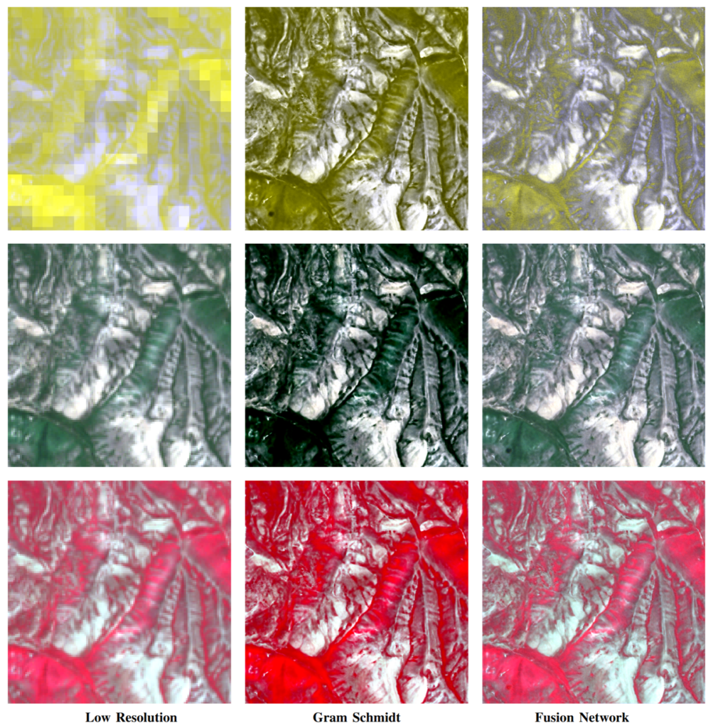
Enhancing all Sentinel-2 bands with AI-based image fusion
An important component in our model, is that it improves all 12 spectral bands of Sentinel-2 imagery, not just the RGB (red, green blue) bands, that most earlier approaches focus on.
To achieve this, we use a neural network-based fusion pipeline that uses the sharpened RGB image as a guide to improve the resolution of the remaining spectral bands. This results in a much clearer and more detailed version of the full 12-band Sentinel-2 image.
The fusion model is trained in a self-supervised way, which means it doesn’t require high-resolution reference images. Instead, it learns by simulating lower-resolution inputs from real Sentinel-2 images and trains itself to reconstruct the original. This approach is inspired by the Wald protocol, a well-established method for evaluating super-resolution models.
Why improved resolution matters
SuperAI enhances multispectral data to make it sharper and more detailed. This supports a wide range of applications, from precision agriculture and land use mapping to climate monitoring and urban planning, where access to reliable, high-resolution satellite information is increasingly important.