Snow monitoring
- Department Image analysis and Earth observation
- Fields involved Earth observation
We utilise satellite data to provide governmental and private entities with crucial information about snow for water management, weather forecasting, avalanche risk management and hydropower, and contribute to advancements in snow property retrieval and climate monitoring.
Seasonal snow is an important component of the Earth system, and heavily affects the energy balance and water cycle at high latitudes and elevations. Snow is one of the major components in the climate system, and it represents a significant storage of water resources. Snow can be hazardous as it can potentially lead to floods and avalanches. Vast land areas in the north and mountains have weak in-situ sensor monitoring due to low population density. Earth observation is the only practical means of frequent and accurate monitoring of snow resources and properties in these regions.
In Norway’s mountainous regions, about half of the precipitation is snow, and several public and private organisations are largely dedicated to solving problems related to snow resources, including The Norwegian Water Resources and Energy Directorate (NVE), the Norwegian Meteorological Institute (MET Norway) and the Norwegian Geotechnical Institute (NGI). As Norway gets most of its electricity from hydropower, the country also has a large hydropower industry that uses snow data to manage rivers, lakes and reservoirs. We work closely with these entities in order to develop methods for retrieving accurate snow information from satellite images and monitor daily changes.
Close to thirty years of experience in fractional snow cover retrieval
Greatly impacted from snow, Norway was one of the first nations in the world to use information about snow from satellite observations, with experiments starting in the 1970s. NR began working for the government-owned company Statskraftverkene (now Statkraft) in the late 1980s, analysing satellite data in order to make snow maps. A decade later, work expanded towards the development of a fully automated system for generating maps of fractional snow cover (FSC), and additional advancements were made in the 2000s with the advent of new satellites and sensors.
FSC is still widely applied at both national and regional level. To use an example in hydrology, the most important snow variable is the snow water equivalent (SWE). SWE means the corresponding volume of water if the snow melts. It is difficult to assess SWE data accurately with current sensors, including passive microwave radiometers (PMR) that measure microwaves emitted from the Earth. Therefore, fractional snow cover remains the preferred method of choice for the hydrological community, especially when the maximum snow accumulation is known or when snow cover becomes patchy during spring. We have extensive experience developing algorithms for FSC retrieval, and currently use approaches in deep learning. We also use deep learning for cloud detection over snow-covered surfaces, an issue that has presented challenges for decades.
Tracking global snow cover changes
From the mid-1990s onwards, we have also been dedicated to algorithmic and technical development, namely large processing chains. This has increased capacity for automated snow mapping in relation to internationally mandated climate monitoring needs issued from entities such as the European Environment Agency (EEA), the Intergovernmental Panel of Climate Change (IPCC), and the UN Climate Convention (UNFCCC).
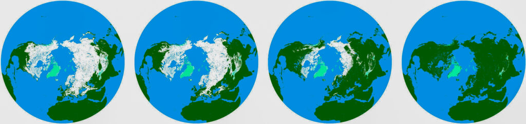
Our involvement in Cryoclim, a collaborative project between NR, MET Norway, NVE and the Norwegian Polar Institute (NP) started in 2008, and has produced significant advancements in the field. As one of the few snow product time series for fractional snow cover, Cryoclim delivers daily maps of the Earth’s global snow cover regardless of clouds and darkness in polar regions. The information extends back to 1982, thus offering a long-term view of snow cover changes.
Today, within the Earth observation programme Copernicus, we are working on advanced algorithms that provide NVE with the most accurate daily maps of snow properties in Norway. We also provide services such as algorithmic development and processing chains to hydropower and trading companies, such as EDInsights.
Other areas of snow monitoring research
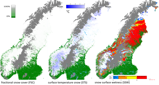
Other important snow properties include temperature, grain size, surface wetness, impurities, hoar frost and albedo, and we use a range of methods to determine these variables.
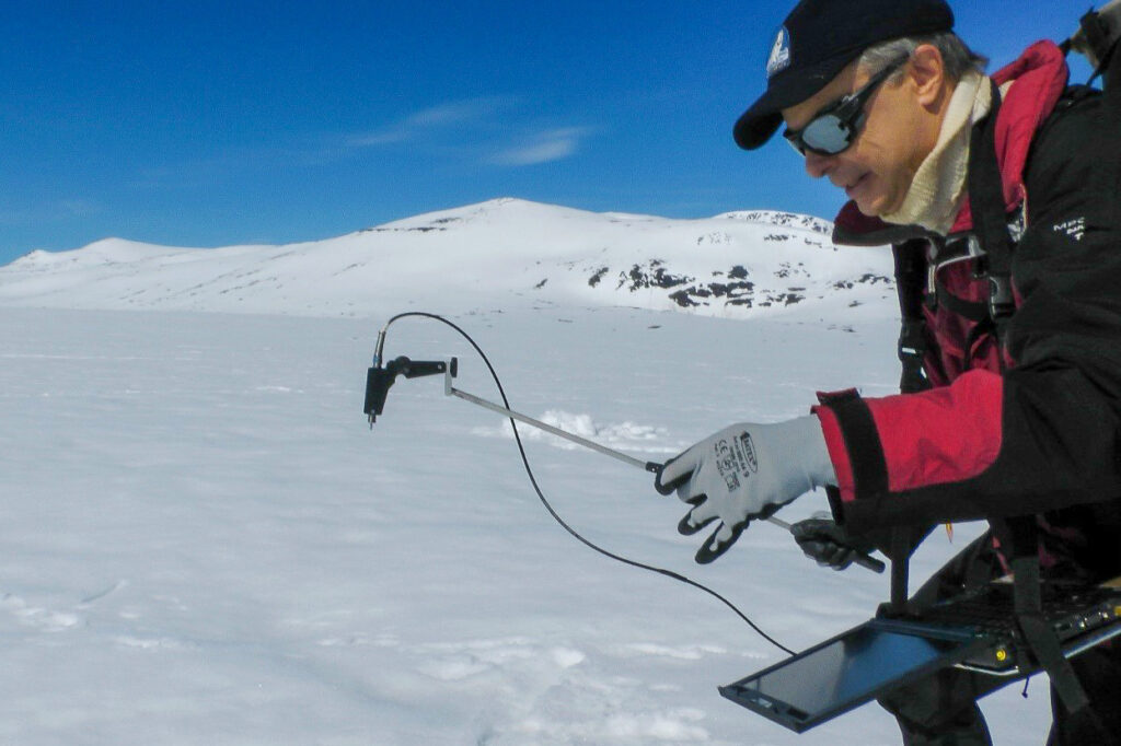
When measuring surface temperature, we look at how different parts of the snow reflect heat, using a method that distinguishes between heat from the air and heat from the ground. This is done using two thermal bands that react differently to the atmosphere. We also perform multiple observations of the same ground area with different path lengths through the atmosphere. We determine grain size by looking at how the snow reflects light, which changes depending on the size of the grains.
Our researchers have also discovered how to measure snow surface hoar by combining satellite data and on-site reports sent to NVE. Snow surface hoar is crucially linked to avalanches in steep terrain and is a notoriously volatile phenomenon. We have developed a retrieval approach based on analysis of surface skin temperature and snow grain size.
Some of our methods are still experimental and will largely benefit from technological advancements such as the ESA hyperspectral sensor CHIME, which is scheduled for launch in 2028. To obtain consistency, we are currently developing a general retrieval model for surface reflectance based on the principles of radiative transfer, rooted in DISORT physics.


Partners and clients:
- EDInsights AS
- Environmental Earth Observation IT GmbH (ENVEO)
- The European Commission
- The Norwegian Geotechnical Institute (NGI)
- The Norwegian Meteorological Institute (MET Norway)
- The Norwegian Space Agency (NOSA)
- The Norwegian Water Resources and Energy Directorate (NVE)
- Statkraft
Selected projects:
- AI for the Arctic (AI4Arctic)
- Climate Monitoring of the Cryosphere – Snow (CryoClim)
- NVE Copernicus 2
- Snow – Climate Change Initiative (Snow_CCI)
- Spectral Snow Model for Sentinel (SnowModel4Sentinel)
Further reading:
Metsämäki, S., Pulliainen, J., Salminen, M., Luojus, K., Wiesmann, A., Solberg, R., & Ripper, E. (2015). Introduction to GlobSnow Snow Extent products with considerations for accuracy assessment. Remote Sensing of Environment, 156, 96–108. https://doi.org/10.1016/j.rse.2014.09.018
Solberg, R., Killie, M., Andreassen, L. M., & König, M. (2014). CryoClim: A new system and service for climate monitoring of the cryosphere. IOP Conference Series: Earth and Environmental Science, 17, Article 012008. https://doi.org/10.1088/1755-1315/17/1/012008
Solberg, R., Koren, H., Amlien, J., Malnes, E., Schuler, D. V., & Orthe, N. K. (2010). The development of new algorithms for remote sensing of snow conditions based on data from the catchment of Øvre Heimdalsvatn and the vicinity. Hydrobiologia, 642, 35-46.
Solberg, R., Salberg, A.-B., Trier, Ø. D., Rudjord, Ø., Stancalie, G., Diamandi, A., Irimescu, A., & Craciunescu, V. (2017). Remote sensing of snow wetness in Romania by Sentinel-1 and Terra MODIS data. Romanian Journal of Physics, 62, 821. https://rjp.nipne.ro/2017_62_9-10/RomJPhys.62.821.pdf