Automated mapping (AutoKart)
- Department Image analysis and Earth observation
- Fields involved Earth observation, Mapping and map revision
In this project, we developed methods for automated mapping combining hyperspectral imaging and deep learning.
Our objective was to automate processes related to updating maps using hyperspectral and laser scanning data taken from aircraft.
Hyperspectral imaging
Hyperspectral imaging gathers and analyses information from across the electromagnetic spectrum, and allows us to locate and categorise objects and materials that wouldn’t necessarily be discerned using standard aerial photography. As a result, the data enables the combination of unique spectral signatures from different surface materials with accurate elevation data.
Deep neural networks
In this project, we obtained simultaneous acquisitions of data across residential areas in Bærum municipality. We used two deep neural networks, namely Mask-RCNN and U-NET, to create methods for object detection which were applied to detect new buildings in the area.
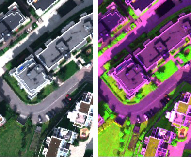
Image: Automated Maps/NR
To learn more about this project, please contact:
Project: AutoKart: Automated mapping using machine learning
Partners: Bærum municipality, Field Group, The Norwegian University of Life Sciences (NMBU), The Norwegian Mapping Authority, and the Norwegian Institute of Bioeconomy Research (NIBIO).
Period: 2020 – 2022